
Overview of Geographic Profiling
Geographic profiling is an investigative support technique for serial violent crime investigations. The process analyzes locations connected to a series of crimes to determine the most probable area in which the offender lives. Geographic profiling should be regarded as an information management system designed to help focus an investigation, prioritize tips and suspects, and suggest new strategies to complement traditional methods.
Stranger violent and sexual crimes are difficult to solve. Investigation can produce hundreds of tips and suspects, resulting in information overload. Police need effective methods of managing and prioritizing the information they collect so resources can be efficiently deployed. Geographic profiling uses analysis of crime sites to determine the likely area of offender residence.
Geographic profiling focuses on:
|
|
| The process was developed from research conducted at Simon Fraser University, and the methodology is based on a model that describes offenders' hunting behavior. The patented criminal geographic targeting algorithm produces jeopardy surfaces, which are 3-D probability surfaces that indicate the most likely area of offender residence. | 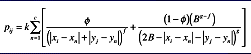 |
The models are displayed through 3-D and 2-D color isopleth maps that provide a focus for investigative efforts.
A Crime-Fighting Tool
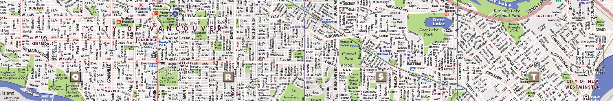
| It's important to stress that geographic profiling doesn't solve cases; what it does is help manage the large volume of information typically generated in major crime investigations. Addresses are common elements in most record systems, and geographic profiling can be used in a variety of contexts as a powerful decision-support tool. Rigel enables law enforcement agencies to make the best use of limited resources. Geographic crime patterns are clues that, once decoded, can point to an offender. | 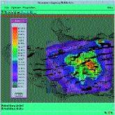 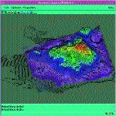 Figures display the jeopardy surface and geoprofile produced from analyzing 32 armed robberies in Vancouver. The geographic profile helped to identify an offender who resided in the top 1% of the geoprofile. |
A Crime-Fighting Tool
It's important to stress that geographic profiling doesn't solve cases; what it does is help manage the large volume of information typically generated in major crime investigations. Addresses are common elements in most record systems, and geographic profiling can be used in a variety of contexts as a powerful decision-support tool. Rigel enables law enforcement agencies to make the best use of limited resources. Geographic crime patterns are clues that, once decoded, can point to an offender.
Figures display the jeopardy surface and geoprofile produced from analyzing 32 armed robberies in Vancouver. The geographic profile helped to identify an offender who resided in the top 1% of the geoprofile.